


Knowledge centerTerrestrial Scanning vs. Mobile Mapping
Both methods produce a registered point cloud with a laser. The difference is whether the sensor stands still while it measures, and that single distinction drives everything else.
Terrestrial: the scanner stands still
Mounted on a tripod, the scanner occupies a fixed, known position and sweeps everything in view. Because the origin does not move, each measurement is referenced to a stable point. Result: millimeter accuracy, and deviation we hold under 0.4 inches across a registered project. Both methods belong to the same 3D laser scanning service.
The cost is time. Each position takes minutes, and complex spaces need many of them.
Mobile: the scanner walks
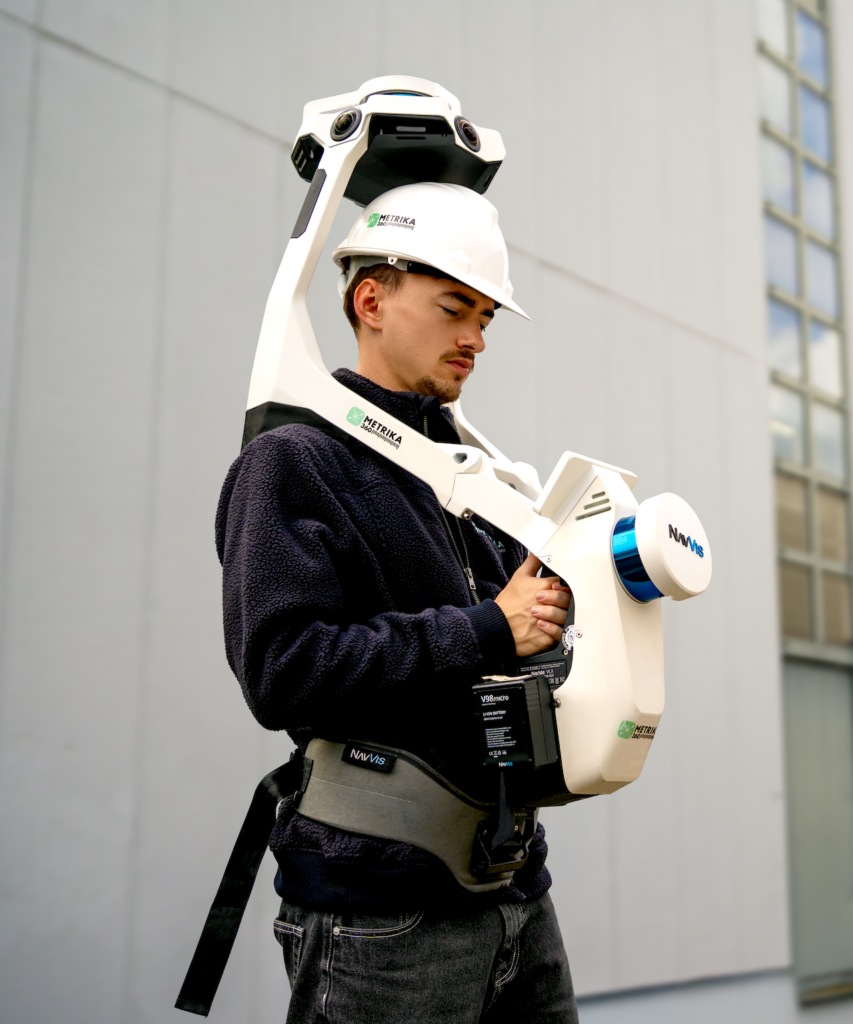
Carried through the building, the system measures continuously while tracking its own movement. Covering ground is dramatically faster — a large floor plate in an hour rather than a day.
The cost is precision. Position is computed rather than fixed, and small tracking errors accumulate along the path. The result is dimensionally accurate, not millimeter-accurate. We use that wording deliberately: where a project needs it stated formally, it becomes a USIBD Level of Accuracy question.
Choosing per area, not per project
The mistake that costs the most money is picking one method for a whole building. Terrestrial everywhere is several times the necessary price. Mobile everywhere produces a cloud that fails the moment somebody details against it.
A typical office project is terrestrial in plant rooms and risers, mobile across the floor plates, drone on the roof — all registered into one coordinate system. The neighbouring terms are in the knowledge center.
How each system knows where it is
Every laser measurement is a distance and an angle from the instrument. Turning many of them into one survey requires knowing where the instrument was, and that is the whole difference between the two methods.
A terrestrial scanner occupies a fixed position while it measures. The origin does not move, so every point in that scan shares one known reference. Positions are then tied together against targets and overlapping geometry, and the joint is checked by measuring loop closure.
A mobile system computes its own position continuously while being carried, combining laser data with inertial sensors. Nothing is fixed, so small errors in the computed track accumulate along the route. Well controlled, the result is dimensionally accurate. Left to run down a long corridor with nothing distinctive to lock onto, it drifts, and the drift is not obvious in the finished cloud.
The two side by side
| Terrestrial | Mobile mapping | |
|---|---|---|
| Position | Fixed occupation, referenced to targets and control. | Computed while moving, from laser and inertial data. |
| Accuracy | Millimeter-accurate. Deviation under 0.4 in across a registered project. | Dimensionally accurate. Not millimeter-accurate, deliberately. |
| Throughput | 32,000 to 65,000 sq ft per day in offices, far less in plant. | Up to 107,000 sq ft per day in open industrial space. |
| Best at | Structure, risers, mechanical rooms, facades, anything detailed against. | Circulation, warehouses, portfolio documentation, area take-off. |
| Fails at | Covering large empty area economically. | Long featureless runs, tight tolerances, movement monitoring. |
| Instrument | Faro Focus on a tripod. | NavVis VLX, carried at walking pace. |
What this does to cost and schedule
Occlusion drives price more than area does. A clear warehouse floor needs a handful of setups; a plant room a tenth of the size can need dozens, because the laser cannot see through pipework. Mobile capture changes the arithmetic only where the space is open enough for walking pace to mean anything.
The practical consequence is that method is chosen per area rather than per project. A typical office building is terrestrial in the cores and risers, mobile across the floor plates, and flown for the roof as a drone survey, all registered into one coordinate system. Choosing one method for the whole building is the single biggest lever on the number, in either direction: terrestrial everywhere costs several times what the project needed, and mobile everywhere produces a cloud that fails the first time somebody details against it.
Where it goes wrong
- One method for the whole building. The expensive mistake, in both directions.
- Mobile data used for detailing. It will look fine on screen. The error appears when a fabricated element arrives on site.
- No record of which method covered what. A deliverable that mixes both without saying so cannot be checked against any USIBD Level of Accuracy, and that is where accuracy disputes start.
- Mobile in a long, empty, repeating space. Racking aisles and blank corridors give the tracking nothing to hold. These runs get tied back to terrestrial control.
- Assuming mobile is always faster. In dense mechanical space it is not, because the limiting factor is what the laser can see rather than how fast the operator walks.
The measuring principle behind both is covered in LiDAR, and the aerial alternative in photogrammetry.
Frequently asked questions
Can the two be combined in one cloud?
Yes, and that is the normal case. Both are registered into the same coordinate system, and we document which method covered which area.
Which is used for scan to BIM?
Both, depending on the area and the level of development. Services modeled at LOD 300 want terrestrial data; a warehouse shell does not.
Can I tell from the file which method was used?
Not from the format, no. E57 and RCP carry either. That is why the method record is part of the handover: which method covered which area, and which areas stayed occluded.
Is mobile mapping enough for a floor plan?
For arrangement, circulation and area, usually yes. For a plan that a fit-out will be detailed against, the core and anything with tight tolerances is captured terrestrially and registered into the same cloud.
Documenting a building?
Tell us what you need measured.