


Knowledge centerWhat Is LiDAR?
LiDAR stands for Light Detection and Ranging. A LiDAR sensor sends out pulses of laser light and measures how long each pulse takes to return. Because the speed of light is known, that travel time gives a distance — and millions of those distances together describe a surface.
How a laser scanner uses it
A terrestrial laser scanner sits on a tripod and sweeps its laser across everything in view, recording a distance and an angle for each pulse. The result is a point cloud: a set of measured points in three dimensions. Move the scanner, scan again, and the individual scans are registered into one coordinate system. A scanner that measures while moving instead of standing still is mobile mapping, which trades precision for speed.
LiDAR is not photogrammetry
Photogrammetry derives geometry from overlapping photographs. It needs light and texture to work, and it infers shape rather than measuring it. LiDAR measures distance directly and works in the dark, which is why it is the method of choice inside buildings, in plant rooms and in ceiling voids.
Where it is used in building documentation
Every deliverable in an existing conditions survey — floor plans, elevations, sections, Revit models — is drawn or modeled from LiDAR data. The point cloud is the measured evidence; the drawing is an interpretation of it, which is why the cloud is worth keeping after the drawings are signed off. Related terms are collected in the knowledge center.
How the distance is actually measured
Two principles are in common use, and the difference shows up in the specification sheet rather than in the deliverable.
Time of flight sends a pulse and counts how long it takes to come back. Longer range, and the method used where a scanner has to reach across a yard or up a facade.
Phase shift sends a continuous modulated beam and compares the phase of the returning signal. Shorter range, very high point rates, and the method most terrestrial instruments use inside buildings.
Either way the instrument records two things per measurement: a distance and the angle it was pointing. Those two values, taken hundreds of thousands of times a second and swept across a room, are the whole of the raw survey. Everything downstream, every plan, section and model, is an interpretation of that.
What a single point carries
- Position. X, Y and Z in the coordinate system of the scan, and after registration in the coordinate system of the project.
- Intensity. How much energy came back. Dark and matt surfaces return less, which is why black rubber flooring and acoustic panels look thin in a cloud.
- Colour. Not measured by the laser at all. It comes from a camera in the same instrument and is mapped onto the points afterwards, which is why colour needs light and geometry does not.
A point knows nothing about what it belongs to. It does not know it is part of a wall, a duct or a parked pallet. Deciding that is modeling, it is done by people, and it is the expensive half of scan to BIM.
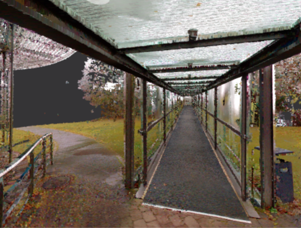
How many scans become one survey
A single scan position sees only what is in line of sight from that position. A building is therefore captured from many positions, and joining them into one coordinate system is called registration.
It is done in two ways, usually together: against targets placed in overlapping areas, and cloud to cloud, by matching the geometry itself. The result is checked rather than assumed. Loop closure, the error you accumulate walking a circuit through a building and back to where you started, is measured and reported. We hold deviation under 0.4 inches across a registered project on terrestrial work, and we state the figure for your project rather than a brochure number.
This is the step that decides whether a survey is usable. A cloud that was never verified can look immaculate on screen and be several inches out at the far end of the building.
What LiDAR is not
- Not photogrammetry. Photogrammetry calculates geometry from overlapping photographs and needs light and surface texture. LiDAR measures distance directly and works in an unlit basement. Full comparison in laser scanning vs. photogrammetry.
- Not radar or sonar. Same idea of timing a signal, different physics and a completely different scale of use.
- Not able to see through anything. Not walls, not ceiling tiles, not the front row of a pipe rack. Whatever the first surface is, that is what gets measured.
- Not a model. A point cloud is evidence, not a deliverable most teams can design in. as-built drawings and Revit models are produced from it.
More terms from the same projects are collected in the knowledge center.
Frequently asked questions
Is LiDAR the same as laser scanning?
LiDAR is the measuring principle. A laser scanner is an instrument that uses it. In building documentation the two words are used interchangeably, and in practice nobody is misled by that.
Does LiDAR work in the dark?
Yes. The instrument provides its own light, which is why plant rooms, ceiling voids and unlit basements are captured exactly as easily as a daylit office. Only the colour overlay needs light.
Can LiDAR see through walls or ceilings?
No. It measures the first surface the pulse reaches. Documenting a ceiling void means lifting tiles, and documenting concealed structure means opening it up or inferring it and labelling the inference.
What file formats does LiDAR data come in?
We deliver registered clouds as E57 and RCP, which open in Revit, AutoCAD, Navisworks and most reality capture software. LAS and LAZ are common in survey and GIS workflows and are available on request.
Is the laser safe around people?
The scanners we use are eye-safe Class 1 devices. No protective equipment is needed by anyone in the space, and there is no reason to clear a floor for scanning alone.
Documenting a building?
Tell us what you need measured and we will come back with the method and the deliverables that fit.